About Summer Trips:
Summer Trips include any human-powered ventures into our outdoor environment from April 1st through November 14th. Our hikes can vary from easy afternoon urban walks to strenuous hikes and overnight backpacks. We hike the trails through deep forest or across lava beds, visit wilderness lakes, climb up rocky crags to high promontories, saunter along ocean beaches, camp near glacier-fed torrents, or stand in admiration of flower-filled mountain meadows. We enjoy bicycle rides ranging from leisurely trips along winding country roads to workouts like 50-mile-plus rides over mountain passes. For boaters, we offer kayak, canoe, and rafting trips on both calm and wild water. From the time of spring blooms to the breakout of fall colors, our aim is to offer a wide variety of opportunities to take an active part in experiencing the wonders around us. |
![]() |
Online Trip signup for an activity is normally enabled three weeks before a trip. Special trips will be available for sign up earlier. Signup via our online signup system, on our home page. Are You Prepared for an Obsidian Trip? For Cold? For Rain? For Sun? For Emergencies? What do you need to know before the trip? On the trail? What are the Ten Essentials? Questions about Summer Trips? Contact: summertrips@obsidians.org Summer Trips' GoogleDocs area can be found here. This includes extra documents managed by the Summer Trips committee, such as copies of recent Permit Area Maps. Trip difficulty ratings: Hint: A hike up Mt Pisgah by the main route would be considered an E (Easy) trip: 3 miles 1000 ft elevation gain.![]() |
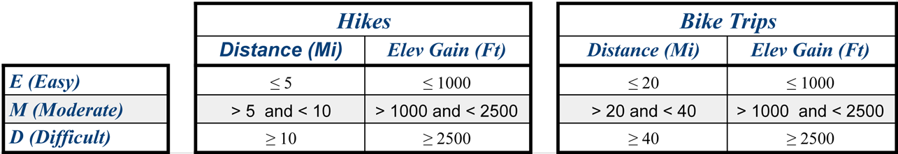
Upcoming Summer Trips:
June
July
August
|
Moderate Hike—Pisgah Long Route w/Options—Sunday, June 4, 2023
Join us for an in-town hike with varying distance options! We will meet at the Mt. Pisgah West (main) Trailhead, by the bathrooms. If you don’t have a Lane County pass, be sure to allow time to purchase one with a Debit/Credit card (no cash) at the fee box by the upper trailhead. Our route will follow the Incense Cedar Trail and Trails 5, 56 and 6 to the summit, where we will gather for water and a snack. At this point, those who prefer a shorter hike can return from the summit directly via main Trail 1, a total of about 5 miles and 2-2.5 hours. To complete the long route, we will descend on Trail 2, then follow Trails 4 and 3 around Swing Hill to the North Trailhead, and finally return to the West Trailhead along the river trail. The complete hike takes about 4 hours for the 9.4 miles. Moderate Bike—Ankeny Hill—Sunday, June 4, 2023
We will meet in the parking lot of the Ankeny Hill Nature Preserve in Jefferson Oregon. Address is 130 Ankeny Hill Rd. SE Jefferson. The route is a loop which we will do clockwise, passing through Sidney Oregon. We will cross the Willamette via the Buena Vista Ferry, heading North along the west side of the river, stopping at the park in Independence for lunch. After lunch we will cross the Willamette, following the river along the east shore, returning to the Nature Center via Buena Vista Road South. It will be a leisurely ride and we will stop to regroup at intersections. Moderate Hike—Blanton Ridge to Spencer Butte—Tuesday, June 6, 2023
This hike to the top of Spencer Butte takes the less traveled route from Blanton Road. We'll cross Blanton Ridge before continuing on from the 52nd and Willamette trailhead. This option provides a good in town workout.. If the weather doesn't co-operate we can forgo the exposed rocky steps near the top. To get to the trailhead from 29th & Willamette continue south on Willamette. At Willamette/Donald St Intersection bear right on Willamette. Immediately bear right again on to Crest Drive. Follow signs staying on Crest for approximately 1.2 miles to the Junction with Blanton Road. Turn left on Blanton. The trail head is on your left in about ½ mile. Do not turn left on Southpointe Dr. Another way to get to the Blanton trailhead is to go south on Chambers until it ends at Crest Drive. Turn left on to Crest. In about ½ mile turn right on Blanton Road. Easy Hike—Evening hike: Baldy/Fox Hollow—Tuesday, June 6, 2023
6 pm: Meet at the trailhead on DILLARD RD & HIDDEN MEADOWS DRIVE. It's a small lot, if there is not enough parking, you can park further up Dillard about 1/4 miles and walk back to meet us. We'll head towards FoxHollow and loop back, then ascend up to Mt. Baldy and return to our cars. It's rated easy due to mileage, however please note the elevation gain. If you have any questions, please give me a call. Easy Hike—Skinner Butte—Tuesday, June 6, 2023
We will ascend the north side of the Butte from the parking lot on old trails and will traverse the summit to the east lookout. Then we will hike down to the relatively new Mid-Elevation Trail and will circle the Butte clockwise. When we come again to the north side, we will hike down and take the trail to the Campbell Center parking lot to see if there is activity at the bald eagles’ nest, then will return to the cars. There will probably still be wildflowers on the Butte. Moderate Hike—Amazon Hdwtrs/Spencer Butte—Wednesday, June 7, 2023
NOTE: Flexible departure time from 7:45 to 8:00. Every Wednesday since 2013 we do this hike from the Martin Street Trailhead to the summit of Spencer Butte. Compared to starting at the paved Spencer Butte parking lot, this hike has double the climbing and three times the distance. It is a conditioning hike where everyone is challenging themselves to go at a moderate or fast pace—not like the other hikes on our schedule. If this is your first time on this Obsidian conditioning hike, or hiking to Spencer Butte, you may want to call the leader to discuss the pace. If you should fall too far behind, the leaders reserve the right to have you not summit but wait and return with the group. The regulars on this hike have attained their fitness by showing up consistently and slowly improving. If you have questions, email summertrips@obsidians.org. Come a few minutes early because we leave promptly at the listed time. To get to the trailhead: Take West Amazon to Martin Street. Turn left. Drive past Kinney Park and park Martin Street near the Kiosk sign board across from Canyon Drive Street sign with hiker symbol. Please contact the leader if you have any questions. easy Hike—Get Acquainted/Ribbon Trail—Saturday, June 10, 2023
Meet at the Obsidian Lodge to start the hike on the Ribbon Trail to Hendricks Park and back. This is an opportunity to find out about the Obsidians, get acquainted with members, and visit our lodge. This hike through the woods has a few short bursts of steep up and down hill. Members are welcome to sign up to help answer questions. Drive past the Laurelwood Golf Course up 27th St then at the top of the hill turn right onto Spring Blvd, a one lane road. When Spring Blvd ends at a T intersection, turn left and immediately look for the Obsidians sign and driveway on your right. Enter the driveway and follow the gravel road to the parking areas and Lodge. The Lodge is hard to find so if you want to view the map, go to the Obsidian home page. http://obsidians.org/lodgemap.htm Moderate Hike—Mt June (via Lost Creek)—Saturday, June 10, 2023
This is a close in hike in the Dexter area. It's a steady climb for about 2 miles, then a "rolling" up and down, and finally a short, steep climb to the former lookout tower at the top. There will be some woodland wildflowers and hopefully, a profusion of flowers at a rock outcropping. Most of the Cascade mountains can be seen from the top. Poles may be helpful for the steep sections. Note: Bill Sullivan's description of the hike starts from a different trailhead. Moderate Hike—Blanton Ridge to Spencer Butte—Tuesday, June 13, 2023
This hike to the top of Spencer Butte takes the less traveled route from Blanton Road. We'll cross Blanton Ridge before continuing on from the 52nd and Willamette trailhead. This option provides a good in town workout.. If the weather doesn't co-operate we can forgo the exposed rocky steps near the top. To get to the trailhead from 29th & Willamette continue south on Willamette. At Willamette/Donald St Intersection bear right on Willamette. Immediately bear right again on to Crest Drive. Follow signs staying on Crest for approximately 1.2 miles to the Junction with Blanton Road. Turn left on Blanton. The trail head is on your left in about ½ mile. Do not turn left on Southpointe Dr. Another way to get to the Blanton trailhead is to go south on Chambers until it ends at Crest Drive. Turn left on to Crest. In about ½ mile turn right on Blanton Road. Moderate Hike—Amazon Hdwtrs/Spencer Butte—Wednesday, June 14, 2023
NOTE: Flexible departure time from 7:45 to 8:00. Every Wednesday since 2013 we do this hike from the Martin Street Trailhead to the summit of Spencer Butte. Compared to starting at the paved Spencer Butte parking lot, this hike has double the climbing and three times the distance. It is a conditioning hike where everyone is challenging themselves to go at a moderate or fast pace—not like the other hikes on our schedule. If this is your first time on this Obsidian conditioning hike, or hiking to Spencer Butte, you may want to call the leader to discuss the pace. If you should fall too far behind, the leaders reserve the right to have you not summit but wait and return with the group. The regulars on this hike have attained their fitness by showing up consistently and slowly improving. If you have questions, email summertrips@obsidians.org. Come a few minutes early because we leave promptly at the listed time. To get to the trailhead: Take West Amazon to Martin Street. Turn left. Drive past Kinney Park and park Martin Street near the Kiosk sign board across from Canyon Drive Street sign with hiker symbol. Please contact the leader if you have any questions. Moderate Hike—Mt June (via Lost Creek)—Sunday, June 18, 2023
This is a longer, out-and-back route to Mt. June, one of the closest places to Eugene to see some great subalpine flowers. We’ll start from the Lost Creek trailhead, which is off of (paved) Eagles Rest Road near Dexter. The trail climbs about 2 miles and 1200 ft. through the forest to a junction with the Sawtooth Trail, follows the ridgeline to the junction with the Mt. June Trail, then climbs a relatively steep half-mile to the summit. We should see a variety of plants and flowers in the forest and on the rocky outcrops, and have some nice views. Exploring a bit around the summit and/or adding about 1.5 miles to the hike to visit Sawtooth Rock are possibilities. Moderate Hike—Yachats to Tillicum beach walk—Sunday, June 18, 2023
We will carpool from Eugene to the Yachats Community Center Parking lot. If needed, a back-up parking option will be the Yachats State Park main parking lot just to the south. The hike will follow the 804 trail to where it ends at a set of wooden stairs down to the beach. We will then walk the beach north for just over 3 miles to Tillicum Beach for lunch, returning the same route back to the cars. The beach walk will cross a few fresh water paths so waterproof shoes (or river sandals if you prefer) could be helpful. Some hikers may choose to stop for a late afternoon snack or beverage in Florence on the way back to Eugene. Moderate CarCmp—Yachats over nighter/beach house—Monday–Wednesday, June 19–21, 2023
Yachats over nighter/beach house, 2 night stay for 8--PLEASE SCROLL DOWN TO READ ALLl. Monday June 19th Drive to Yachats beach house and then to Amanda Trail hike to see the suspension bridge and the statue. Back to the house for potluck. Planning details to follow. Tuesday morning take bus to Walport walk back on beach -- 8 mi; option to get off bus halfway at Tillicum 4 miles .. Med difficulty... Tuesday evening go to restaurant or eat at house. $65 contribution towards professional cleaning and Tuesday breakfast provided by Scott sleeping arrangements -- One room -- King bed, for 2 to share Second room -- Queen bed for 2 to share Third room -- 3 singles Floor space, couches Coordinating emails to follow for people signed up. Send check to Scott Hovis at 294 W 22nd Ave, Eugene, OR 97405 by five days after signing up. Moderate Hike—Blanton Ridge to Spencer Butte—Tuesday, June 20, 2023
This hike to the top of Spencer Butte takes the less traveled route from Blanton Road. We'll cross Blanton Ridge before continuing on from the 52nd and Willamette trailhead. This option provides a good in town workout.. If the weather doesn't co-operate we can forgo the exposed rocky steps near the top. To get to the trailhead from 29th & Willamette continue south on Willamette. At Willamette/Donald St Intersection bear right on Willamette. Immediately bear right again on to Crest Drive. Follow signs staying on Crest for approximately 1.2 miles to the Junction with Blanton Road. Turn left on Blanton. The trail head is on your left in about ½ mile. Do not turn left on Southpointe Dr. Another way to get to the Blanton trailhead is to go south on Chambers until it ends at Crest Drive. Turn left on to Crest. In about ½ mile turn right on Blanton Road. Moderate Hike—Amazon Hdwtrs/Spencer Butte—Wednesday, June 21, 2023
NOTE: Flexible departure time from 7:45 to 8:00. Every Wednesday since 2013 we do this hike from the Martin Street Trailhead to the summit of Spencer Butte. Compared to starting at the paved Spencer Butte parking lot, this hike has double the climbing and three times the distance. It is a conditioning hike where everyone is challenging themselves to go at a moderate or fast pace—not like the other hikes on our schedule. If this is your first time on this Obsidian conditioning hike, or hiking to Spencer Butte, you may want to call the leader to discuss the pace. If you should fall too far behind, the leaders reserve the right to have you not summit but wait and return with the group. The regulars on this hike have attained their fitness by showing up consistently and slowly improving. If you have questions, email summertrips@obsidians.org. Come a few minutes early because we leave promptly at the listed time. To get to the trailhead: Take West Amazon to Martin Street. Turn left. Drive past Kinney Park and park Martin Street near the Kiosk sign board across from Canyon Drive Street sign with hiker symbol. Please contact the leader if you have any questions. Moderate Hike—Mt Pisgah Summer Solstice—Wednesday, June 21, 2023
Sunset is at 8:59 (Moonrise is 8:28 am) Look for us by my car, two or three rows down from the fee box at the gate. Current plan is take Trails 7,3, and 1 to summit. Faster hikers usually include a section of Trail 4. If heat is an issue, I might change start time so that everyone can take shady Trail 4. Email me at jbjacobsen@comcast.net if you have questions. Our goal is to view the rays of the sunset shining through the Mt. Pisgah Sighting Pedestal. For more info about the pedestal, see the June 2021 Bulletin. www.obsidians.org/bulletin/Issues/2021_Bulletins/2021_06_Bulletin.pdf Email jbjacobsen@comcast.net if you have questions. If it is raining, we will not linger Easy Hike—Evening hike: Pre's Trail—Thursday, June 22, 2023
6:00 pm: Meet in the parking lot near the duck pond and frisbee golf course, this is the lot on the left right after you cross the bridge coming into Alton Baker Park. The trail surface is a mix of hard pack and dirt. If you have any questions, please give me a call. Moderate Hike—Pisgah East Side Loop—Friday, June 23, 2023
To get to the east trailhead head drive toward Pleasant Hill on hwy 58. Turn left at the 76 station on to Ridgeway Rd. The parking area is 1.7 miles down this road. We will hike to the summit on trails #2, 4 and 1 and then return using trail #6. The parking lot is small but vehicles sometimes park on the road if there isn't room. You need a Lane County pass to park but not if you park on the road. |
Past Summer Trips:
Reports on Past Trips:
2023
2022
2021
2020
2019
2018
2017
2016
2015
2014
2013
2012
2011
2010
2009
2008
2007
2006
2005
2004
2003
2002
2001